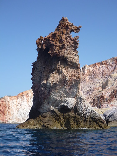
May have a new blog title image :)

Rod saved the longest and toughest paddle trip for my last day. Joined again by Greek paddlers George and Olga, our aim was to paddle right around the island of Kimolos. Sitting 1 km off the north-east of Milos, Kimolos has a population of about 2,000 people settled on the southern and eastern shores. The circumnavigation is a 27km round trip from the town of Pollonia on Milos.
Our initial plan was to do a clockwise trip but on arrival at our launch beach in the middle of Pollonia we were faced with a stiff force 4 south-easter. We decided to reverse the direction of the trip in order to get a start with the long headwind slog and keep the shorter one for the end of the trip when more tired. The first leg then saw us paddling into the headwind for a 5km leg along the south coast of Kimolos to the south east edge. 55 minutes later we reached the loading gantry marking the point and turned left to make our way NE then N up the coast.
Here we had a mix of conditions with some headwind due to topographic effects then a cross then following sea with some swell. We passed the harbour village of Psathi below the main town, Kimolos. As we made our way more north we encountered a lot of clapotis close to the shore making for an interesting ride. Just short of half way up the coast segment was a pair of off shore low arches with the second requiring a quick left turn after going through the first in order to successfully negotiate. Quite a lively interlude with amplified swell and rebound but I emerged dignity intact. For the rest of this leg we hung further offshore to avoid the clapotis and make the most of the sea.
As we rounded the NE edge of the island we could see another bentonite mine. Finally we had the full benefit of a following sea and tailwind, heading on a short NW leg before rounding Cape Pouli and heading more westerly. We cut straight across the wide Monastiria Bay. The land to our left was more steeply sloped with little habitation. Some where crossing the bay we passed our halfway mark. We had some large rollers helping along on this leg, evidence of the swell.
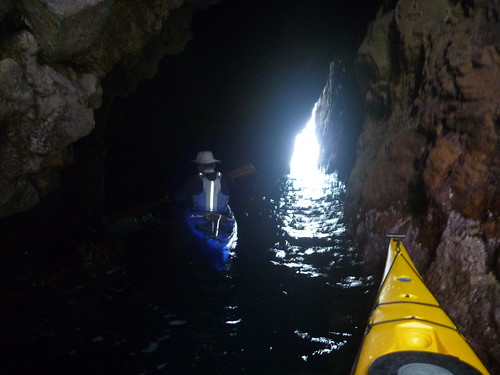
Approaching the most northern point of the island, Cape Gherakia, we could see a few lower pinnacles and land masses below the main cape. Rod directed to keep left where we soon saw a gauntlet between the actual cape and the rocks. Our side was rough due to swell and rebound but shooting through the other side was dead calm and sheltered from wind and swell. We swung a hard light and into the rocks which turned out to be a delightful series of arches, tunnels and caves called the Labyrinth.
One arch had collapsed since last year but the main cave had several entrances, some open to the ocean swell and lovely lighting. After playing around here for a while we continued along the calm sea SW to our lunch spot, about 15 minutes paddling. We pulled onto a small beach, one of a pair in a small bay. The valley was uninhabited but had lots of stone terraces, dating back to antiquity. Olga, being in the front of the double kayak, had copped a wet ride so appreciated the chance to change, dry out and make the most of the intermittent sun whilst we had lunch. We had been paddling for 3 1/4 hours non stop till this point, exceeding their previous longest paddle trip.
After a 45 minute lunch break we headed off for the homeward paddle. Tracking SW down the coast the harsh, rugged nature of the land was evident. From memory I can only recall seeing one habitable building along this stretch off steep valleys and cliffs. It started to rain along this stretch but luckily only lasted a few minutes. Eventually we reached Cape Petalidha and turned south, picking up a quartering wind though we still had shelter from the cliffs on our left.
Once we reached Tsi Kalis the land dropped in height and a bay opened up, exposing us to the SE headwind and wind waves. We waited for a ferry to come from our right and go south. Cutting across the bay we used Aghios Andreas islet then Cape Kambana to protect us from the full extent of the wind then reached Pollonia Channel for the final crossing. Here we felt the full effect of the force 4 headwind. Selecting a transit point on the headland south of Pollonia we set off for the final 2km slog. I was slower than Rod or the pair in the double but plugged away at it.
Eventually I passed the small point marking the entrance to the open mouth of the beach and boat ramp at Pollonia and could swing right, cutting through a gap between two sections of just submerged rocks with breaking waves. Now I had some almost surf able waves pushing me ashore. Surviving a momentary scare with a large wave just before the beach I finally landed after 6 hours, 5 1/4 of those in the kayak.
Rather weary but happy to have completed the week on such a high I was pleased to land. It had been a great 6 days of paddling along the coast of Milos and nearby islands. Rod runs a great business with Sea Kayak Milos which itself is a wonderful, diverse place to paddle. Yes, you can get lovely calm blue seas and sea caves but you can also have challenging conditions and committing day trips. Thoroughly recommended!
My fifth day of paddling saw Rod and I back at picturesque Firopotamus. Our plan was to paddle out of the bay and then left, around to Plathiena Beach where we had launched on my first paddle trip. We would then cross to the Akradhia islands off the mouth of Milos Bay.
The weather was clear and sunny for this trip, enticing us to hug the shoreline and explore the gauntlet, arches and odd sea cave or two once we rounded Cape Spilia on the very north of Milos. Rod was on a mission to find some driftwood planks to replace those washed away from his lunch spot on the smaller of the islands.
This section of coast also hosts a large purlite mine, clearly visible from the sea. After making it to Plathiena and sighting the Bears again we headed back up to Cape Ladikha before making the 1km crossing to the larger of the dramatic Akradhia islands.
It rises 250m above the sea with no safe landing spot anywhere on the island. Paddling along the east coast then left and down along the north west coast we were ale to sit in close to the base of the cliffs. Rod pointed out the large section of a fish farm washed ashore, a jumble of black plastic piping. I'd seen other remnants along the main coast of Milos earlier that day and on my first paddle. We crossed to the north coast of the smaller island before swinging around it, picking up a tail wind and larger seas.
Fortunately the tiny landing site was still viable so we pulled ashore at the base of the steep rise. Shedding our pfds and spray decks we then started the 120m climb up to the lighthouse on top of the western edge of the island. Along the way we inspected the small church and were treated to a stunning vista of Milos, Anti Milos and the larger of the Arkahdia islands. The light house is now unmanned but still operational. The interior of the main building is dilapidated but accessible.
After lunch and sunning ourselves back down by the boats we launched for the crossing back to Milos. We headed straight for Cape Spilia, using the following sea and tail wind to our advantage. The clear skies gave me good views of Kimolos and Sifnos and I could even view Serifos in the distance. Pulling back into the small bay with Firopotamus I paused to take several photos from the kayak in glorious sunlight.
Not the longest or hardest paddle of my trip but another really enjoyable day on the water.
Following a rest day notable for cold weather and a howling wind (blog post to follow) it was great to be back on the water with the promise of Sun. For this paddle trip Rod and I were joined by Alexia, one of Rod's daughters, Nicholas, his nephew and two Greek teachers on holiday, George and Olga, who had their own double kayak. Today's trip along the south coast was to take us from the beach at Psathi to the jewel of Milos' coast, the sea arches at Kleftiko and back, a distance of 17km.
I paddled through a small arch t the left of Psathi as the others got ready then we headed west in a calm sea with some residual swell from the southerlies of the last few days. It is impossible to recount every sea cave we explored or entered on this trip or the even greater number we paddled past as there were simply too many of them!
A few highlights stand out though. One, a seasonal bat cave was long, large and dark due to a dogleg in it. We used torches to probe the inner chamber whilst sloshing about in the reflected swell. No bats were present at this time of year though. Another one with a twin rocky smaller entrances was called the dragon's cave by Alexia. Further along the coast we could spy one of the sea stacks at Kleftiko in the distance and a massive loading facility from a adjacent mineral mine closer.
We paddled beneath the loaders and noticed caves beside them. Soon we found another set of cave with multiple entrances that cut through from one side of a small outcrop to another. I spent some time paddling through, around and connecting back through passages, an amazing experience.
The Sun had been toying with us as we paddled towards Kleftiko, finally emerging just as we arrived to illuminate the white rock and volcanic ash of the arches. I delighted in paddling through the arches, caves and tunnels in a variety of directions. The water was stunningly clear and sunlit. Eventually I caught up with the others who had landed at a narrow, impermanent beach at the base of the cliff where we had lunch and relaxed.
After lunch I had time for some more weaving through the caves and arches before starting our return leg. Olga and George soon set their kayak sail to make the most of the tailwind. Alexia decided she wanted to splash me with her paddle and start a water fight. I resisted, for now...
We bypassed most of the caves on the return leg but Rod encouraged me to run a rock gauntlet. He and Alexia made it successfully through in their double. Nicholas then tried but got his angle and timing wrong, coming to grief and capsizing as a wave caught him in the sucky channel. Luckily I was close behind so was able to get him to swim back holding his kayak whilst I grabbed his paddle and hand-towed the boat. Once out of the immediate danger zone we emptied his boat and he was able to reenter. Turned out that this was the first time he had capsized other than in training. All went well.
Shortly after this we paddled toward a narrow tunnel that I had noticed on the outbound leg but ignored due to the swell through it. Fortunately this had dropped just enough for us to now give it a go. Rod cautioned that getting the correct line was critical and went first. They got through on the back of a wave and it looked relatively benign. I followed and and successful negotiated the narrow entrance when I felt myself picked up and suddenly surging through the slot less than 1m wide. The constriction in the channel meant I was accelerating the whole way through, popping out the other end and narrowly missing Rod and Alexia waiting there. What a buzz! Rod decided he needed another go so I waited there and filmed them coming through. Luckily they caught the same sort of wave as me so came through at great speed, just missing me.
Once we were in sight and closer to the pull out spot I finally relented and gave Alexia the water fight she was after. She lost. Hopefully now she has a better appreciation of the correct technique for employing paddles in a water fight.
All up an amazing day's paddle with some incredible caves, tunnels and arches plus sun.
My third day of sea kayaking on Milos was to prove a bit less strenuous than day two. For this trip I was joined by Rebecca and rebecca, two US students studying in Europe. We picked them up in Adamas and headed to our launch site, little cove beside the fishing village of Mandrakia on the northern coast of the island. The main goal of today's paddle was to explore the sea caves along the coast to the famous beach and cove at Sarakiniko, east of Mandrakia.
Although only short in distance this leg took quite some time as we explored a variety of caves and sea canyons cut into the volcanic ash. I needed my headlamp in one as it went in quite a way and round a bend. We were sheltered from the SW wind but there was still a gentle swell that was amplified in a few of the narrow chutes and caves. What at first looked like rubbish in the water turned out to be small lumps of pumice broken off from the cliffs.
We went along as far as the ship wreck of a coastal trader that ran aground in the 80s. A mast leaned out an angle above the water along with a few other segments of the hull but most was below water or gone.
After exploring the wreck we pulled into the narrow white cove at Sarakiniko and onto a small beach. Rebecca and Rebecca were eager to try the famous cliff jump from the white ash cliffs into the clear (but cold!) sea. Rod and I decided that our skills were better used in photographing their attempts. They each made two jumps, first from a low cliff then one much higher. When I get my photo issue fixed I'll post some up. This cliff line had some strange uprights sticking out of the rock that were the remnants of a wharf built here by the Germans in WWII when thy occupied the island.
After a snack we headed back the way we came and back past our launch spot. We headed west to our lunch spot, passing the island's desalination plant, the source of their water, on the way. Rounding a small headland with a ruin on it we pulled a lovely cove with a beach and the hamlet of Fryopotamos. All the buildings were deserted, it is evidently a weekender and summer vacation spot for locals. We had a pleasant lunch in front of the beach cabin that when open would be renting beach chars and selling snacks. We had the place to ourselves however apart from a young German couple who arrived just as we were exploring the church below the ruin on the headland.
For some reason Rebecca had been cold during lunch as the Sun kept toying with breaking through the clouds but never making it for long. Anyone would think she'd been jumping in the water!
The Sun came out for our headland exploration then it was back in the kayaks for the trip home. Along the way we pulled into the tiny harbour of the village of Mandrakia, a very picturesque spot with some lovely small vessels moored and the church in the background. Some of the locals were in their boathouses that are dug into the cliff face, with only the brightly painted doors showing.
A short paddle back around to our starting cove finished a lovely day's paddle. After getting back to Petrinella's Guesthouse and a welcome shower it was time to explore on land. Rebecca and Rebecca were catching the 9.30pm ferry to Santorini so we decided to go up to the village of Plaka first then head down to the port at Adama by taxi and have a celebratory seafood dinner there.
As we made our way up to Plaka we passed the football ground with a match in progress. Turns out to be the annual match between the two Dynamite Clubs ahead of the Easter Sunday explosive festivities (blog post with details to follow). Plaka was what you picture a Greek village to be but it was rather windy! It climbs up the hill to the base of the rock outcrop atop which sits the Castro, originally a Venetian lookout and fortification. We decided to climb up the path, the wind battering us all the way. The view from the top was pretty spectacular but it was hard to take photos as the wind kept trying to rip the camera out of my hand.
A hasty retreat back to village level saw us finish our exploration of the laneways. Our walk back past the football ground coincided with the end of the match and several large explosions as supporters of both teams detonated their homemade bombs! As we were getting into our taxi at the Guesthouse the street was blocked by a procession lead by one of the teams on a truck with followers atop and following in cars. They couldn't get any further so everything ground to a halt right beside our taxi that was then trapped for several minutes. Everyone jumped off the truck and let off more explosives almost beside us.
We eventually made it down into Adamas and found a nice-looking seafood restaurant just as the rain that had been forecast all day arrived. Given the choice of cold, ind and rain or a warm restaurant we took the second option and wined and dined till the ferry was due. The restaurant was notable for the number of cats underfoot, one of which took particular interest in the girls' food supplies they were taking to Santorini.
Eventually I headed off for a taxi back up the hill comfortable in the knowledge that I would soon be in warm bed. Rebecca and Rebecca had a two and a half hour ferry ride to Santorini, arriving at midnight after which they would have to find their way to the campground and pitch their tent. Hope you made it OK!
Another great day of paddling and meeting new friends.
My second day of paddling was to prove a lot more challenging than the first due to the strong SW winds, up to Force 7. Rod had selected the most feasible route down the west coast of the island to an old sulfur mine. We launched beside the Varitine Factory, a large mine for bentonite on the NE edge of the island. 20% of the world supply of this valuable mineral comes from this mine which is the largest employer on the island. Paddling south down Voudhia Bay, hugging the coast we avoided the worst of the force 4 headwinds but were exposed to side winds coming down the small valleys.
The wind picked up once we rounded Cape Kastanas but we were still able to enter a sheltered sea cave. Occasional gusts kept me honest against the strengthening wind that had picked up to force 5. Shortly after rounding Cape Roma we landed on a small beach, Paliorema, that had a boathouse and ruined building. During the 16th century the biggest revenue earner for the Greek region were the millstones mined in the little valley leading up from the now deserted beach. Seems hard to imagine now but it shows how ephemeral things are.
Whilst having a snack we examined the various worn rocks in a washout just above the sea line. Rod quickly realised that many of the rocks were not from the island. He started to assemble a sample of the different types, arranging and classifying them according to their igneous and metamorphic types. As far as I could figure out the rocks may have been brought to the island as ballast for the ships then dumped nearby so they could load the millstones.
Continuing southward we passed our planned lunch spot after 500m but kept going to round the adjacent headland to experience the larger swell of the more exposed coast. Had a fun 10 minutes of slogging into the strong wind and swell before turning around and back for lunch.
Approaching our lunch spot on Thiafes Beach was another Raiders of the Lost Ark-like scene. The site is an abandoned sulfur mine, now ruined. Buildings were stepped up the side of the slope with an amazingly steep rail track alongside. as the wind would howl down the valley and blow dust and tailings out into the tiny bay we sheltered in the sunny southern edge by a stone wall. The mine was established in the 1930s and shut down in the 50s. It was still maintained till the 80s so all the visible decay had taken place since then, evidence of the harsh, windy environment. Actually the mine was only the most recent in the valley, the Romans had mined here two millennia ago.
I explored whilst Rod relaxed. The site is a photographer's dream, grit and dust not withstanding. I was able to clamber through a series of interconnected buildings still full of derelict machinery and roofs. As we had lunch the wind increased and the waves picked up.
The positive for the return trip was that we expeteced a tailwind, now force 7. the downside were the gusts that seemed to come from any direction and down fron the small valleys. The trickiest bit was just getting out off the beach and out of the tiny bay. I was getting blown sideways from the wind from the valley but eventually made it up past Paliorema. Once past Cape Roma the tailwind and seas were generally helpful but I couldn't relax.
Crossing Voudia Bay back to the launch site was generalll flatter but then a strong crosswind down a large valley complicated matters. By the time we landed back at the factory I felt satisfied with a challenging 13km paddle.
(OK, cannot seem to access my photos on Flickr for some strange reason, have to r=try and publish the accompanying photos later).
Awaking far too early as usual I went for a stroll to get the lay of the land and get some shots before the Sun got too high. I strolled down past a church to the bridge separating Triovasalos and Pera Triovasalos then back up the hill and up to the village of Plakes from where I could see the Castro atop the pinnacle at the edge of the village. This was a key lookout in Venetian times.
Rod met me for breakfast and we discussed the morning plans. We selected some kayaks, me in. Temoest 170 from Wilderness then headed off for the short drive to a lovely little beach, Plathiena, on the northern side of the island. Our plan was to paddle acros the mouth of the main inlet of the island on which the port of Adamas sits then up past an old mine and around to Cape Vani. We expected a headwind for the crossing which though supposed to strengthen, would give us a tail wind back at the end of the day.
It was a beautiful, sunny day, the warmest so far this Spring according to Rod. Soon after setting off we came to an interesting pair of stacks called "the Bears" after the shape of the main one. From the angle we approached it seemed more like the Trojan Rabbit from Monty Python and the Holy Grail but it was certainly colourful with interesting weathering. The crossing to the other side was uneventful and the wind not strong at all.
Once on the other shore we made north along till we got to the old manganese mine. We planned to come back there for lunch. We then paddled past the old wharf, quite a dramatic structure then around Cape Vani. Rounding the point we found the sea and wind remarkably calm so decided to head on to the first beach along the western coast, Angathia. Before that Rod directed me to what initially seemed like just a rock face. On paddling closer I noticed a small crack that Rod then proceeded to paddle into. Turn out to be a narrow slot, just wider than a kayak, that cut through the small headland to the other side. Very photogenic and a wonderful start to the trip.
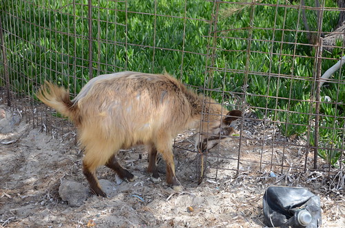
Angathia was deserted apart from flock of goats, most of whom took off when we landed. One stayed behind, trying to eat the pig face through a fence protecting it. This little garden was adjacent to a small house, empty, at the top of the beach. The goat kept bleating and on investigation I found it was stuck as it could not pull head and horns back through the wire gap in the fence. I called over Rod so we could try and free it. Brute force to snap the fence didn't work but eventually with two of us we were able to manipulate the goat's head back through the opening after which it took off without any thanks. There was an old dinghy above the beach that made for an interesting photo.
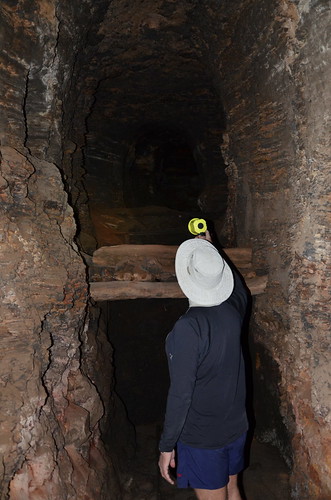
Heading back to Cape Vani we explored another sea cave then back through the slot, around the Cape and landed at the mine. The site was a manganese mine, deserted several decades ago but with several ruined buildings and some equipment rusting. After lunch we headed off to explore a mine tunnel that Rod had visited once but only gone a short way in. This time, equipped with headlamps we were ale to explore to the end. There were several tunnels and shafts and we found the remnants of the small railway used for hauling the black ore. Looked like something from Raiders of the Lost Ark.
The paddle back across to our launch spot was uneventful save for having to wait for a ferry to cross our path. This time we headed around the outside of the Bears before arriving back at the beach. Total distance paddled was about 20km. All in all a very pleasant start to my kayak adventures with some unusual shore excursions. Looking forward to more!